 |  |

European discovery of the River Murray system: The Overlanders
Display Thesaurus-Associated Content
Listing for term 'exploration'
 |
The maritime portion of South Australia |
|
|
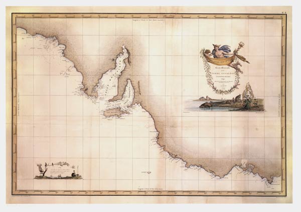 |
Carte generale de la Terre Napoleon [map] |
|
|
 |
The River Murray above Moorundi |
|
|
 |
Bejah searched for water |
|
|
 |
Decision to abandon outfit and collections |
|
|
 |
Wells and Jones leave on side trip |
|
|
 |
Poor camel feed |
|
|
 |
Shallow watercourse seen |
|
|
 |
Saw crows and footprints |
|
|
 |
Six camels reported ill |
|
|
 |
Still some four days from Joanna Springs |
|
|
 |
Some camel feed found |
|
|
 |
A few drops of rain fell |
|
|
 |
The expedition nears Joanna Spring |
|
|
 |
Wells walks 12 miles with a half pint of cold tea |
|
|
 |
Eyre climbs Mount Distance |
|
|
 |
Mt Hopeless is climbed |
|
|
 |
Eyre describes the extent of the salt lake |
|
|
 |
Eyre describes Lake Torrens |
|
|
 |
Eyre decides to turn back |
|
|
 |
Wylie: Edward Eyre's companion |
|
|
 |
Eyre's track in 1840-41 |
|
|
 |
Australian exploring expedition in the scrub |
|
|
 |
The burden of leadership |
|
|
 |
Queen Victoria Springs discovered |
|
|
 |
The explorers had a bath |
|
|
 |
Conflict of interest with another expedition |
|
|
 |
Gibson continues on alone |
|
|
 |
The last day Giles saw Gibson |
|
|
 |
Giles staggers on with a water keg |
|
|
 |
Giles reaches safety after parting from Gibson |
|
|
 |
Giles and Tietkens set out to look for Gibson |
|
|
 |
The search is called off |
|
|
 |
Babbage finds Coulthard's body |
|
|
 |
Separation Well and cache of meat: diary 26 May 18 |
|
|
 |
Insufficient firewood to boil the billy : diary 27 |
|
|
 |
Kilroy returns alone : letter 8 September 1846 |
|
|
 |
Gill sketched the country : letter 8 September 184 |
|
|
 |
Horrocks decides to use a camel : letter 8 Septemb |
|
|
 |
Horrocks sets out with Gill and Kilroy : letter 8 |
|
|
 |
Horrocks terminates the expedition : letter 8 Sept |
|
|
 |
The expedition waits for their gear to dry |
|
|
 |
No rain in night but heavy overcast : diary entry |
|
|
 |
The ridges are big and irregular on top : diary en |
|
|
 |
An excellent harbour is found |
|
|
 |
Field and Pullen each explore the inlet |
|
|
 |
Light again explores the inlet |
|
|
 |
Light begins his search for the harbour |
|
|
 |
Light considers ranges would produce rain |
|
|
 |
Light continues down the coast |
|
|
 |
Patawalonga River discovered |
|
|
 |
Onkaparinga mouth is examined |
|
|
 |
Abundant grass and plentiful water |
|
|
 |
Another channel to the creek discovered |
|
|
 |
The prospects ahead looked good |
|
|
 |
Sturt considers whether to explore the creek |
|
|
 |
Sturt decides to continue to the north |
|
|
 |
The prospect ahead is cheerless |
|
|
 |
The men and horses are exhausted |
|
|
 |
Salt water creek and sand-hills |
|
|
 |
The sand ridges rose higher and higher |
|
|
 |
Symptoms of scurvy among the men |
|
|
 |
Condition of the horses to be considered |
|
|
 |
Spinifex and interminable ridges of sand |
|
|
 |
Sturt turns back from the desert |
|
|
 |
Terra Australis charted |
|
|
 |
Cape Northumberland charted |
|
|
 |
Strangways and Hutchinson set out |
|
|
 |
Currency Creek is discovered |
|
|
 |
The boat is stove in by a snag |
|
|
 |
Hindmarsh Island is named |
|
|
 |
The expedition turns back |
|
|
 |
Night travelling over poor country |
|
|
 |
How to cook a camel |
|
|
 |
A camel foot needs to be boiled for 36 hours |
|
|
 |
Charley locates water |
|
|
 |
Charley is praised for his efforts |
|
|
 |
Warburton barters for fresh meat |
|
|
 |
Emerald Spring discovered |
|
|
 |
Burtt is sent out to link up with Warburton's main |
|
|
 |
Burtt finds a path through the horseshoe lake |
|
|
 |
Lewis describes Lake Eyre as useless |
|
|
 |
Map of Lake Eyre |
|
|
 |
Goyder finds luxuriant grass and an extensive lake |
|
|
 |
Freeling attempts to float a boat |
|
|
 |
Misconceptions of the fertility of the land |
|
|
 |
Hack finds good pastures west of Lake Gairdner |
|
|
 |
Summary of work done |
|
|
 |
Lindsay continues his summary |
|
|
 |
Expedition reaches Skirmish Hill |
|
|
 |
Expedition reaches Moses Creek |
|
|
 |
LA Wells' report of his side trip, 14 to 17 July |
|
|
 |
Wells continues his report of his side trip |
|
|
 |
Camel dies from eating poisonous vegetation |
|
|
 |
Queen Victoria Springs is dried up |
|
|
 |
The search for Bryan |
|
|
 |
Report of an expedition to Lake Alexandrina |
|
|
|
Geology of country bordering Lake Alexandrina |
|
|
 |
Junction of the supposed Darling with the Murray |
|
|
 |
Planting the flag on the shore of the Indian Ocean |
|
|
 |
Central Mt Stuart |
|
|
 |
Stuart's path is blocked by a marsh |
|
|
 |
The north coast of Australia is reached |
|
|
 |
The flag is raised at Chambers Bay |
|
|
 |
Memorandum on Central Mount Sturt |
|
|
 |
Discovery of Ayers Rock: diary 19 July 1873 |
|
|
 |
The most wonderful natural feature ever seen: diar |
|
|
 |
Ayers Rock |
|
|
 |
McKinlay decides to build a punt |
|
|
 |
The expedition reaches Escape Cliffs |
|
|
 |
McKinlay's route from Adam Bay to the East Alligat |
|
|
 |
Swinden's diary |
|
|
 |
South Australia appears on the world map |
|
|
 |
Stuart's Glandfield Lagoon: diary 25 May 1861 |
|
|
 |
Confrontation with Aboriginal men: diary 26 May 18 |
|
|
|
Woodforde compelled to fire: diary entry 26 May 18 |
|
|
 |
Stuart continues to search for a path forward |
|
|
 |
Ayers Rock discovered and named |
|
|
 |
Gosse continues his diary |
|
|
 |
Sea mouth of the Murray |
|
|
 |
Junction of the Murray and Lake Alexandrina |
|
|
 |
South Australia at the time of settlement |
|
|
 |
Model handbook for explorers |
|
|
 |
The members of the expedition |
|
|
 |
Objectives of the expedition |
|
|
 |
Starting point for the expedition |
|
|
 |
Previously discovered permanent waters |
|
|
 |
Return route and search for Leichhardt: instructio |
|
|
 |
Tree blazing and mapping instructions |
|
|
 |
Stores, provisions and correspondence |
|
|
 |
Instructions to the second officer and the surveyo |
|
|
 |
Spelling of Aboriginal words |
|
|
 |
Pronunciation of Aboriginal words |
|
|
 |
Report of a voyage from Sydney to Kangaroo Island |
|
|
 |
Water easy to find by digging |
|
|
 |
Abundant fish and a good harbour |
|
|
 |
The island is fertile and well wooded |
|
|
 |
Salt is produced in abundance |
|
|
 |
Climate of Kangaroo Island |
|
|
 |
Aboriginal women taken from the mainland |
|
|
 |
Australia begins to appear on the world map |
|
|
 |
Terra Australis nondum cognita |
|
|
 |
Pacific Ocean |
|
|
 |
James Cook |
|
|
 |
Tasman's ships Zeehaen and Heemskerck |
|
|
 |
Kangaroo Island emu |
|
|
 |
Flinders map of South Australia |
|
|
 |
Westall's view of Kangaroo Island |
|
|
 |
Flinders meets le Geographe |
|
|
 |
Baudin's activities before the meeting |
|
|
 |
Flinders explains his geographical findings |
|
|
 |
Peron claims Terre Napoleon |
|
|
 |
Flinders denies Peron's claims |
|
|
 |
Flinders believes Peron was over-ruled |
|
|
 |
Flinders continues his survey |
|
|
 |
Flinders names Encounter Bay |
|
|
 |
Terre Napoleon |
|
|
 |
Flinders names restored |
|
|
 |
Coastal profiles of South Australia |
|
|
 |
Three explorers set out |
|
|
 |
Walking on a salt lake |
|
|
 |
Australia circumnavigated: General chart of Terra |
|
|
 |
East side of St. Vincents Gulf |
|
|
 |
Special surveys in South Australia |
|
|
 |
Plan of Overland Telegraph Line |
|
|
 |
Water at last |
|
|
 |
36 hours without water |
|
|
 |
Christmas for the explorers |
|
|
 |
Ross reaches Central Mount Stuart |
|
|
 |
On Stuart's tracks |
|
|
 |
Stuart's Central Mt Sturt |
|
|
 |
Ascending Mount Sturt |
|
|
 |
Sir Douglas Mawson |
|
|
 |
Horrocks' Expedition |
|
|
 |
In the Musgrave Ranges |
|
|
 |
Mt Unapproachable or Mt Harris? |
|
|
 |
Aboriginal names or European? |
|
|
 |
Mt Gambier climbed |
|
|
 |
Rivoli Bay surveyed |
|
|
 |
Grey's wallaby |
|
|
 |
Horses are daily weaker |
|
|
 |
Discovery of garnets |
|
|
 |
Explorers dig for water |
|
|
 |
Grave of a white man found |
|
|
 |
McKinlay finds other traces of Burke and Wills |
|
|
 |
Horn expedition at Bagot's Creek |
|
|
 |
Horn expedition finds plenty of water |
|
|
 |
Horn expedition scientific staff well satisfied |
|
|
 |
Grey's route |
|
|
 |
Mackay Expedition map |
|
|
 |
Chart of Cape Jervis |
|
|
 |
Corroberribera |
|
|
 |
Elizabeth Creek |
|
|
 |
Pernatty Creek |
|
|
 |
Coulthard found |
|
|
 |
Pernatty Creek and sand cliffs |
|
|
 |
On Stuart's Creek |
|
|
 |
Emerald Spring |
|
|
 |
Emerald Spring described |
|
|
 |
Lake Torrens country |
|
|
 |
Babbage's map |
|
|
 |
This country is a perfect desert |
|
|
 |
Stuart's route to the Hugh |
|
|
 |
MacDonnell Ranges to Kekwick's Ponds |
|
|
 |
Unknown north |
|
|
 |
Stuart's route to the north |
|
|
 |
Simpson Desert explorations |
|
|
 |
Murat Bay charted |
|
|
 |
Burtt's path through the lake |
|
|
 |
Sandringham Station misplaced on the maps |
|
|
 |
Disruptive camels and dry wells |
|
|
 |
Hay River gum flats |
|
|
 |
Aerial views of the Mulligan and Simpson Desert |
|
|
 |
Sturt's explorations |
|
|
 |
Pass in Rowe's Creek |
|
|
 |
Sir Joseph Banks |
|
|
 |
Chaining over the sandhills to Lake Torrens |
|
|
 |
Jimmy locates water |
|
|
 |
Nature of the interior |
|
|
 |
Sturt seeks an inland sea |
|
|
 |
Sturt's letter to Morphett |
|
|
 |
Sturt recognised by Aboriginal men |
|
|
 |
Sturt means to uncover the interior |
|
|
 |
Has Poole found the inland sea? |
|
|
 |
Eyre's concept of the interior |
|
|
 |
Advantage of Aboriginal guides to explorers |
|
|
 |
Naming of Flinders Ranges |
|
|
 |
Objects of exploration |
|
|
 |
Navigating at sea |
|
|
 |
Navigating on land |
|
|
 |
Daily meteorological observations |
|
|
 |
Incentive to explore Australia |
|
|
 |
Banks suggests Mungo Park to explore Australia |
|
|
 |
Baron Sir Ferdinand von Mueller |
|
|
 |
The expedition starts out |
|
|
 |
Explorers toast the Queen's birthday |
|
|
 |
Australia must have a great river |
|
|
 |
Mystery of the unknown south coast |
|
|
 |
Flinders' instructions |
|
|
 |
Details of explorations to be recorded |
|
|
 |
Survey Torres Strait |
|
|
 |
The plant cabin |
|
|
 |
Conclusion of Flinders' instructions |
|
|
 |
Elder Exploration Expedition setting out |
|
|
 |
Blazed tree at Mt. Cooper |
|
|
 |
Near Lake Deborah |
|
|
 |
Forrest Rock Hole |
|
|
 |
Creek in the Everard Range |
|
|
 |
Ayers Rock (Uluru), Central Australia |
|
|
 |
Colson's Expedition across the Simpson Desert |
|
|
 |
Bejah and Warrior |
|
|
 |
Aunger drives a Dort across river |
|
|
|
Ayers Rock |
|
|
|
Carte generale de la Terre Napoleon |
|
|
|
The maritime portion of South Australia |
|
|
|
James Cook |
|
|
|
Kangaroo Island emu |
|
|
|
Kangaroo Island emu |
|
|
|
Channel of Cooper Creek discovered |
|
|
|
Australia must have a great river |
|
|
 |
Frome's instructions to surveyors |
|
|
|
Chaining over the sandhills to Lake Torrens |
|
|
|
Climate of Kangaroo Island |
|
|
|
Flinders' instructions |
|
|
|
Condition of the horses to be considered |
|
|
|
Details of explorations to be recorded |
|
|
|
Mr. Eyre decides to turn back |
|
|
|
Mr. Eyre describes Lake Torrens |
|
|
|
Mr. Eyre describes the extent of the salt lake |
|
|
 |
Eyre's expedition leaves Adelaide |
|
|
|
Mr. Eyres concept of the interior |
|
|
|
Mr. Eyres expedition leaves Adelaide |
|
|
|
Field and Pullen each explore the inlet |
|
|
|
Horrocks' expedition: letter 8 September 1846 |
|
|
|
The maritime portion of South Australia |
|
|
|
Carte generale de la Terre Napoleon |
|
|
|
Tasman's ships Zeehaen and Heemskerck |
|
|
|
Terra Australis nondum cognita |
|
|
|
Pacific Ocean |
|
|
|
Australia begins to appear on the world map |
|
|
|
South Australia appears on the world map |
|
|
|
Australia circumnavigated: General chart of Terra |
|
|
 |
Part of South Australia [cartographic material] |
|
|
|
Flinders map of South Australia |
|
|
 |
Scene on the Coorung near Lake Albert |
|
|
 |
View from Mount Lofty across the Adelaide Plains |
|
|
|
Kangaroo Island emu |
|
|
|
Pass in Rowe's Creek |
|
|
|
Junction of the supposed Darling with the Murray |
|
|
|
Nature of the interior |
|
|
|
The River Murray above Moorundi |
|
|
|
Salt water creek and sand-hills |
|
|
|
Sturt recognised by Aboriginal men |
|
|
|
Map of Captn. Sturt's route from Adelaide into the |
|
|
 |
The River Murray, near Lake Alexandrina |
|
|
|
The search for Bryan |
|
|
|
Abundant fish and a good harbour |
|
|
|
Chart of Cape Jervis |
|
|
|
Geology of country bordering Lake Alexandrina |
|
|
|
Greys wallaby |
|
|
|
Junction of the Murray and Lake Alexandrina |
|
|
|
Light continues down the coast |
|
|
|
Mt Hopeless is climbed |
|
|
|
Report of an expedition to Lake Alexandrina |
|
|
|
Part of Southern Australia from 132 to 141 degrees |
|
|
|
Light considers ranges would produce rain |
|
|
|
Mr. Eyres routes into Central Australia, and overl |
|
|
 |
Research yacht Penola under sail |
|
|
 |
Two of Rymill's dogs |
|
|
 |
De Havilland Fox Moth on the sea ice |
|
|
 |
Map of Graham Land 1928 |
|
|
|
Climate of Kangaroo Island |
|
|
|
Eyre climbs Mount Distance |
|
|
|
Flinders names restored |
|
|
|
S.E. extremity of South Australia to illustrate Go |
|
|
 |
Lacepede Bay depicted |
|
|
|
Murat Bay charted |
|
|
|
South Australia appears on the world map |
|
|
|
The River Murray, near Lake Alexandrina |
|
|
|
Wylie: Edward Eyre's companion |
|
|
|
Flinders names Encounter Bay |
|
|
 |
Diary of Young Bingham Hutchinson |
|
|
 |
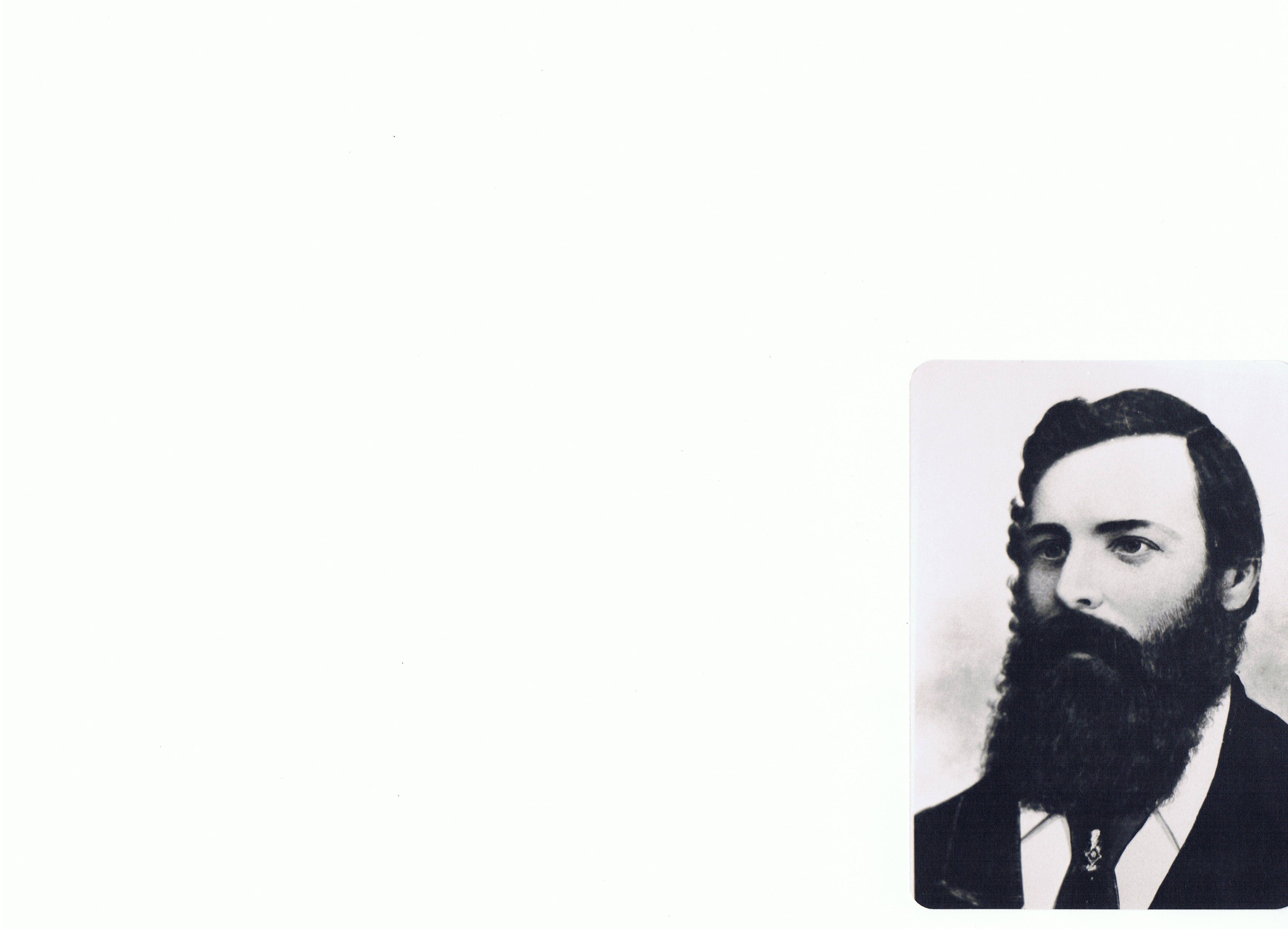
Henry Hawson |
|
|
|
Map shewing the special surveys in South Australia |
|
|
 |
Prewitt's Springs |
|
|
 |
Scene in Adelaide |
|
|
 |
View of Narien Range |
|
|
 |
View of the Gulph [sic] and the Port from the hill |
|
|
 |
Frome Bridge |
|
|
 |
Australia, map featuring SA and the 'horseshoe' |
|
|
 |
Australia, map from surveys made by order of the B |
|
|
 |
Crater of an extinct volcano |
|
|
 |
Encampment |
|
|
 |
Gawler Town |
|
|
 |
Glen Osmond Toll House, near Adelaide |
|
|
 |
Halting Place at the Cavern, Rowe's Creek |
|
|
 |
Hendersons Creek (dry) |
|
|
 |
Narien Range |
|
|
 |
Preparing to start |
|
|
 |
Wallaby Springs |
|
|
 |
Weeping tree |
|
|
|
Light considers ranges would produce rain |
|
|
 |
Diary of William Webster Hoare |
|
|
 |
Scrapbook of Northern Australia |
|
|
 |
S.A. Northern Pioneers: John McDouall Stuart |
|
|
 |
S.A. Northern Pioneers: F.W. Thring |
|
|
|
Corroberribera |
|
|
|
Pernatty Creek and sand cliffs |
|
|
 |
Crater of Mount Schank |
|
|
|
Sturt's letter to Morphett |
|
|
 |
Sketch of the country north of Mount Remarkable [S |
|
|
 |
Fitzroy Gold Fields, Port Curtis showing the route |
|
|
 |
Plan of the settled districts of South Australia |
|
|
|
Corroberribera |
|
|
|
Pernatty Creek and sand cliffs |
|
|
 |
Journal of Edward Dowsett (pages 1-8) |
|
|
|
Australian exploring expedition in the scrub |
|
|
|
Cape Northumberland charted |
|
|
|
Central Mt Stuart |
|
|
|
Uluru (Ayers Rock) |
|
|
|
Crater of Mount Schank |
|
|
 |
Journal of Edward Dowsett (pages 9-18) |
|
|
 |
The continent revealed |
|
|
 |
Reedy Creek |
|
|
 |
Black Rock Hills |
|
|
|
Pass in Rowe's Creek |
|
|
 |
Pass in Rowe's Creek [sketch] |
|
|
 |
Eagle's Nest Hills |
|
|
 |
River near Mount Serle |
|
|
 |
Mr Poole's, Glen Osmond near Adelaide |
|
|
 |
Glen Osmond new road, near Adelaide |
|
|
 |
Pasmore River |
|
|
 |
Ridleys Steam Mill near Adelaide |
|
|
 |
Devil's Glen |
|
|
 |
Mundys Valley, Mount Bryan |
|
|
 |
Drive through the Scrub (Hawker and Henderson) |
|
|
 |
Black Rock Hills depot |
|
|
 |
Part of the Black Rock Hills |
|
|
 |
Distant view of Reaping Hook Hill |
|
|
 |
Smoker's Valley |
|
|
 |
A stormy night in the bush |
|
|
 |
Chase of a kangaroo |
|
|
 |
Bank of South Australia [North Terrace] |
|
|
 |
Rapid Bay (cliffs and coastline) |
|
|
 |
Calypso's Grotto, Rapid Bay |
|
|
 |
Valley of the Inman [River] |
|
|
 |
Rapid Bay |
|
|
|
Plan of Overland Telegraph Line |
|
|
|
Flinders map of South Australia |
|
|
|
Babbage's map |
|
|
|
Burtt's path through the lake |
|
|
|
Elizabeth Creek |
|
|
|
Emerald Spring |
|
|
|
Emerald Spring described |
|
|
|
Lake Torrens country |
|
|
|
On Stuart's Creek |
|
|
|
Pernatty Creek |
|
|
|
Pernatty Creek and sand cliffs |
|
|
|
Walking on a salt lake |
|
|
|
MacDonnell Ranges to Kekwick's Ponds |
|
|
|
Memorandum on Central Mount Sturt |
|
|
|
Planting the flag on the shore of the Indian Ocean |
|
|
|
Stuart's route to the Hugh |
|
|
|
Stuart's route to the north |
|
|
|
Unknown north |
|
|
|
Charley is praised for his efforts |
|
|
|
Map of Lake Eyre |
|
|
|
Model handbook for explorers |
|
|
 |
Getting to know the Antarctic: Discovery's trip |
|
|
|
Discovery of Ayers Rock [Uluru]: diary 19 July 187 |
|
|
 |
Report from E J Eyre, Feb 1842 |
|
|
|
Report from E J Eyre, Feb 1842 |
|
|
 |
Hume River (Murray River) discovered |
|
|
 |
Hume and Hovell's marked tree |
|
|
 |
Sturt describes his whaleboat |
|
|
 |
Assistance from Aboriginal peoples |
|
|
 |
Sturt charts the river |
|
|
 |
Murray mouth |
|
|
 |
Junction of the Darling and Murray |
|
|
 |
Barker's expedition |
|
|
 |
Barker Monument, Mt. Barker |
|
|
 |
Gawler's expedition up the Murray |
|
|
 |
Colonel George Gawler |
|
|
 |
Who discovered Lake Alexandrina |
|
|
 |
Public dinner to Mr Hawdon |
|
|
|
Memorandum on Central Mount Sturt |
|
|
|
Lacepede Bay depicted |
|
|
 |
From hope to tragedy |
|
|
Search Again
Copyright and this website | Contact us | Accessibility | Disclaimer | Privacy | Research enquiries | FOI | ||