 |  |

The dwindling River: Droughts and floods
 Droughts
The definition of 'drought' is complex, and dependant on different factors such as location and climatic zone. Droughts are generally accepted to be prolonged periods of abnormally dry weather, with scarcity of moisture having an adverse effect on vegetation and animal life in an area. Droughts have obvious direct effects on freshwater ecosystems by reducing water levels and availability. However, droughts also induce damaging indirect effects, such as the conversion of a flowing stream or river into a series of stagnant pools which may lower water quality with lower oxygen levels and higher levels of dissolved organic matter.
Drought often carries with it negative connotations, with images of dying sheep and cattle. However, we must recognise that drought events are a natural part of many ecosystems and may play an important role in the functioning of these ecosystems. A Symposium on the Role of Drought in Aquatic Ecosystems was held in Albury, Australia in February 2001. View the synopsis of the Symposium here.
Prior to the 1860s droughts were scarcely noticed as most settlers were living in areas with reliable rainfall. It was the drought of 1864-65 which led to the drawing of Goyder's 'line of rainfall' indicating the limit of the rainfall which separated lands suitable for agriculture from those fit for pastoral use only. It marked areas of reliable and unreliable annual rainfall, and was pivotal in raising awareness for South Australian settlers of the limits for successful agriculture.
The current drought which is affecting the Murray-Darling system is said to be equal to the worst droughts of the last century, and is shaping up to be worse than the last experienced in 1983.
Over the last 100 years since accurate records have been kept, South Australia has experienced several severe droughts which affected the River Murray in South Australia in the following years:
- 1884-86
- 1895-98
- 1901-03
- 1911-15
- 1927-29
- 1943-46
- 1959
- 1961
- 1967
- 1976-77
- 1982-83
The early push for irrigation followed some very serious droughts, with many contemporaries of the time concluding that the only way to secure water for development was to dam the rivers.
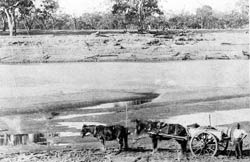
In its natural state, the River Murray was quite different from the present day regulated river. During severe droughts it was sometimes reduced to a chain of waterholes which made the river too unreliable to enable intense settlement in South Australia.
As part of any natural river feature, droughts and floods are part of an ancient, natural cycle. However, where the Murray would naturally experience drought flows once every 20 years, it now experiences artificially induced drought conditions in six of every 10 years.
Unlike the early pastoralists, hydrologists today are aware that the frequent droughts which occurred in the 19th century, and the above-average rainfall in the second part of the twentieth century, are a feature of the highly variable climate in Australia.
 Floods
Generally speaking, flooding in the River Murray is caused by climatic events beyond South Australia, such as abnormal snow melt in the Snowy Mountains in New South Wales and Victoria.
Apart from periods of major flood, the River Murray now runs low in winter, spring and early summer, when it previously flooded regularly, and runs high in late summer and the early autumn, when previously it often ran low. This impact is reduced further downstream due to the flow coming from rivers such as the Loddon, which do not have major storages to capture winter rain (the Loddon system comprises storages, weirs and connecting channels which integrate the supply of water from the Campaspe and Loddon River catchments. These have been built gradually over decades beginning in the late 1880s, the early 1940s and through to the mid 1950s and 1960s. To find out more about some water storage systems up the Murray go to:
Since accurate records have been kept, floods have occurred in the Murray-Darling system in:
- 1867 Disastrous flood on the Murrumbidgee River. For the Murray, a 1 in 90 year flood, with the 4th highest level ever recorded at Albury (NSW) and 2nd highest at Echuca (Vic)
- 1870 First officially recorded flood. Peaked 11M at Morgan. It washed away homesteads at Craignook [117ml] and Murbko [177ml]
- 1890 Darling flood peaked 8.25M at Morgan.
- 1917 Flood reached 9.7M at Morgan.
- 1931 Flood peaked 9.8M at Morgan and breached some levees.
- 1952 Flood peaked 8.6M at Morgan.
- 1955 Flood peaked 8.3M at Morgan and pre-empted the 1956 flood.
- 1956 Flood peaked 12.3M at Morgan, breached all levees and was the highest flood recorded since white settlement. Traditionalists argue that it was only the 'locks' that made it higher than the 1870 flood.
- 1974 Flood peaked 8.5M at Morgan (old annual floods peaked about 5-7M, but by 1974 the Snowy Mountains Water Management Scheme, designed to 'even out' the Murray's fluctuations, was fully operational.)
In South Australia, a River Murray flood is considered exceptional when the water level is more than 5 metres above pool level. In South Australian recorded history this has occurred in 1931, 1956, 1973 and 1974.
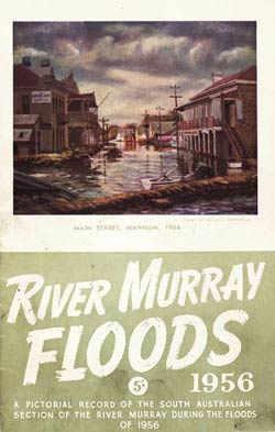
The 1956 River Murray flood is considered to be the greatest natural catastrophe in South Australia's history and is the largest flood ever recorded in the state. It occurred as a result of excessive and late rains in the western districts of Queensland, and heavy rains commencing three months earlier than usual in the Murray catchment areas. The Darling and the Murray were both in high flood at the same time. During floods the waters in the River Murray system spread out below Tocumwal in NSW and engulf the Edward and Wakool rivers, forming one huge lake which helps to control flooding further downsteam by acting as a natural reservoir. In 1956 the usual spread of waters below Tocumwal could not hold the quantity of water and the swollen river raced on its way though South Australia (Mortimer, p 7, 1985) causing widespread damage to agricultural properties and townships. This flood resulted in the construction of the Menindee Lakes storage areas to store high Darling River flows.
Further reading
Dunn, John MA. 1966 The effects of war and drought on the economy of South Australia 1914-1918. Thesis -- [University of Adelaide?]
Fenner Conference on the Environment (3rd: 1989: Canberra, ACT), 1991, Conservation in management of the River Murray system - making conservation count: proceedings of the third Fenner Conference on the Environment, Canberra, September 1989, [Adelaide]: South Australian Dept. of Environment and Planning for Australian Academy of Science
Grosvenor, G. Arch. The Murray pioneer 1956-57 flood diary / compiled by G. Arch Grosvenor [Renmark, S. Aust.: Murray Pioneer Pty. Ltd.], 1957
Harrison, G. L, 1957 Report on the River Murray flood problem, with particular reference to the 1956 flood. Maribyrnong: Dept. of Defence Production, Central Drawing Office
Mortimer, Peg. Flood, Riverlanders face the flood of fifty-six, Berri, S.A.: P. Mortimer, c1985
River Murray floods, 1956: a pictorial record of the South Australian section of the River Murray during the floods of 1956 [Adelaide, S. Aust.?: s.n., 1957?]
Links
ABC Television: GNT History: 1956 Murray flood
Commonwealth Bureau of Meterology: Drought

|
Mannum floods |
|
|

|
Moving stories of the floods |
|
|

|
Murray blockage |
|
|

|
Murray flow to sea stops |
|
|

|
P.S. Murrabit discharging stone for Lock 6 |
|
|

|
P.S. Wanera in Lock 4 |
|
|

|
River Murray floods, 1956 |
|
|

|
River Murray floods, 1956 : a pictorial record of the S |
|
|

|
River Murray Floods, The Adelaide Chronicle, 27 August |
|
|

|
River Murray in flood |
|
|

|
River Murray in flood |
|
|

|
Sand bag barrage built over a low River Murray at Waike |
|
|
Items 13 - 24 of 28
Copyright and this website | Contact us | Accessibility | Disclaimer | Privacy | Research enquiries | FOI | ||